


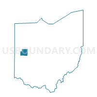
ANNA VILLAGE Voting District, Shelby County, Ohio
About
Outline

Summary
| Unique Area Identifier | 651634 |
| Name | ANNA VILLAGE Voting District |
| County | Shelby County |
| State | Ohio |
| Area (square miles) | 0.84 |
| Land Area (square miles) | 0.84 |
| Water Area (square miles) | 0.00 |
| % of Land Area | 99.97 |
| % of Water Area | 0.03 |
| Latitude of the Internal Point | 40.39590700 |
| Longtitude of the Internal Point | -84.17394660 |
Maps


Graphs
Select a template below for downloading or customizing gragh for ANNA VILLAGE Voting District, Shelby County, Ohio


